A Microadventure in Edale
On the last Saturday of January I packed a few things into my rucksack and caught a train to Edale. I was off on what Al Humphreys has named “a microadventure”:
A microadventure is an adventure that is close to home: cheap, simple, short and yet very effective. It still captures the essence of big adventures, the challenge, the fun, the escapism, the learning experiences and the excitement.
My plan was to sleep out in the open, without a tent. When I set off I wasn’t sure where I’d be calling home for the night, but that decision seemed best left until evening.
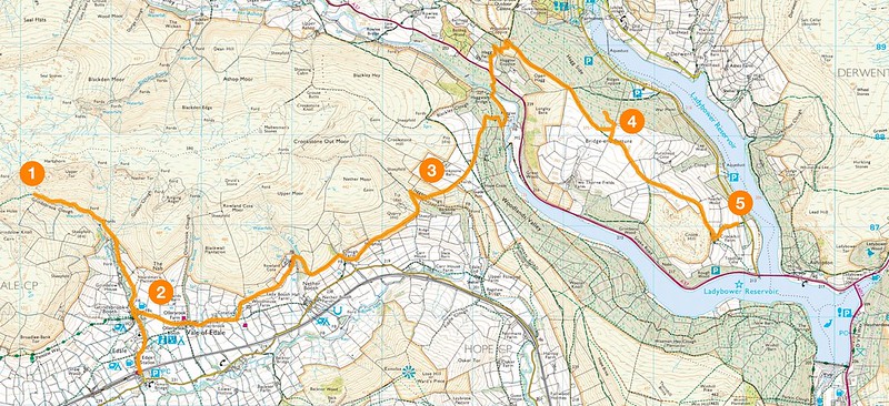
I fancied sleeping on the southern slopes of Kinder Scout, but walking up Grinds Brook (see [1] on the map below) soon put me off that idea. The higher I went the colder it got, and when it started snowing I got a taste of just how inhospitable it might get during the night. I didn’t have enough experience to know whether I’d be warm enough in my bivvy bag, so decided to find somewhere more sheltered.
Click the map to view a larger version on Flickr.
I retreated to the Nag’s Head (see [2] on the map), ate a hearty lunch (I recommend the carvery), and had a good look at my OS map.
One of the attractions of bivvying is the possibility of waking up to a good view. From the map it looked as though I might be able to find somewhere overlooking the Ladybower reservoir, so I headed east along the Vale of Edale.
It was three o’clock when I left the Nag’s Head, and I knew the light would fade fast. It was a blustery day, so I wanted to find somewhere sheltered from the wind. The map showed plenty of dry stone walls near Backside Wood (just south of [3]), and I suspected they’d serve the purpose nicely.
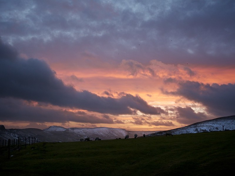
The walking along the valley was pleasant and quick, and I was at Edale YHA in no time (it’s just north of Nether Booth). As I carried on towards Backside Wood the sun was setting behind me, casting long shadows over the hills on the other side of the valley.
When I reached Backside Wood it didn’t feel like a great place to stop. The hillside was too steep and I was enjoying the walk, so I climbed up out of Jagger’s Clough [3], looking back to find a wonderful sunset unfolding behind me.
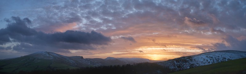
“Tonight”, I thought, “this is my bedroom…”
I realised that I didn’t have a good idea of where I might sleep. I was already surprised I couldn’t see Ladybower reservoir, but had at least learned that I needed to find somewhere flatter to spend the night.
I was still attached to the idea of waking up with a view of the water. As I surveyed the terrain before me I could see a plantation on top of a hill, and realised it was Bridge-end Pasture [4]. It was only a couple of miles away, but it would certainly be dark by the time I’d get there. I thought I might be able to get there, pitch camp, and then head on to the pub a few miles beyond in time for a quick pint.
Bridge-end Pasture [4] looked, on paper, like a great spot. The thin black lines on the map suggested dry stone walls (which would provide shelter from the wind), and there would certainly be a view of the water from the top. The ground also looked reasonably flat.
I briefly considered whether I would be stupid to walk on in the dark, before remembering the night hikes I’d done many years ago as a Venture Scout. We used to walk long distances through the Peak District at night, navigating with a map, compass and (weather permitting) the stars. If I could do it when I was 17, I could sure as hell do it now. And damn it all, I was on an adventure!
At the entrance to the woods above Haggwater Bridge I paused to photograph the last of the sunset, then met a small group of mountain bikers on their way back to Hope. We exchanged hellos, and went our separate ways (though they later found me online, via the Facebook Microadventure group).
The rest of the walk to Bridge-end Pasture was straightforward, and I arrived shortly after 6pm. Unfortunately, I’d failed to notice that it’s marked as a marsh on the OS map, and the ground was heavily waterlogged. In the fading light I’d mistaken the markings for dirt on my map case!
There was also very little shelter, as most of the supposed dry stone walls were actually wire fences. A cold south westerly was blowing over the hill, and I felt exposed. I ventured into the plantation, where the ground was dry, but tree roots were everywhere. Flat patches large enough to sleep on were scarce.
The large pine trees were old and fragile. Everywhere I looked large branches or entire trees had been blown down by the wind, and I could imagine one landing on me in the night. I found a small clearing covered in snow, criss-crossed by deer tracks. It was a cold and eerie place, as the wind whistled through the tree tops.
I started clearing a patch of snow with my boot, wondering how hard it would be to setup my tarp between some small trees, but quickly gave up. It was a special place, and it felt like a privilege to be experiencing it alone at night, but I didn’t want to stay. At this point I didn’t know for certain whether I’d be able to keep warm. It would also have meant giving up on my quest to wake up with a view of the reservoir…
I looked to the map for another place to sleep. I could see a small copse of trees just east of Crookhill Farm [5]. I’d started to worry that most of the hill would be waterlogged (leaving me with a long walk ahead), but large trees suggested the ground in a copse would be fairly firm. They’d also provide some shelter from the wind; the copse would make a good bolt hole.
I returned to the path and set off south east towards Crook Hill. It was very dark by now, and the path was hard to see. I soon lost track of it, and found myself walking through open bog. I should have put my gaiters on, but my hands were cold and my trousers already wet. The wind was still blowing, and I didn’t want be there. It was time to setup camp. I paused, reconsidering the snow-covered clearing.
For some reason, I was concerned about getting lost in this boggy field. It’s amazing how darkness can affect your outlook. Looking at the map now I can see it would have been very difficult to get seriously lost – there’s a field boundary every few hundred yards. What concerned me at the time was how long I’d have to spend wandering about in the cold. I was tired, and didn’t have enough snacks to keep walking for hours on end. Accurate navigation in the absence of a path seemed important.
I crossed the first field on a compass bearing, delighted to see a styal appear out of the gloom as I reached the other side. I set off across the next field on a new bearing. Pairs of eyes reflected my torchlight back at me out of the darkness, as I scanned for any sign of a wall or fence that might indicate where I was.
When I encountered a track running across my path I had no idea which one it was (there are several to the west of Fearfall Wood). I took a bearing from the peak of Crook Hill, whose silhouette against the dark cloudy sky was the only landmark I could make out. The bearing confirmed it – I was on course.
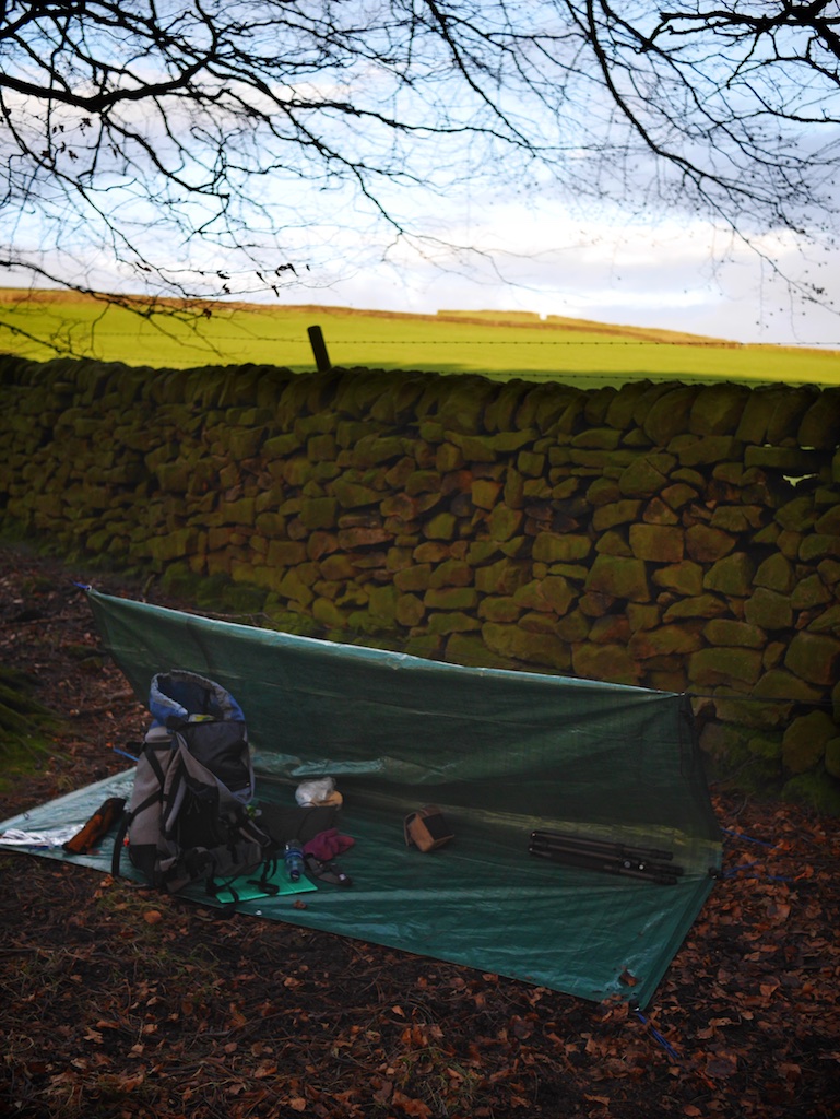
I reached another styal at the head of a lane. All that remained was an easy stroll past the farm, before I arrived at the copse. The wall and trees provided a little shelter, but it was still very windy. I decided to rig the tarp.
Half an hour later I was tucked into my sleeping bag, eating bread and cheese and watching an episode of Spiral on my iPad (I do love BBC iPlayer). Wind was whistling through the tarp, but the homely feeling of familiarity it provided (I'd rigged it in the back garden earlier in the week) was very welcome.
Twenty minutes later I’d given up on Spiral (edgy drama probably isn’t the best start to a long night’s sleep in a strange wood), and got my head down for the night.
The next morning I woke up to find myself in a field of very inquisitive sheep. They were attracted to the sound of a tarp blowing in the wind, no doubt used to feeding on food wrapped in tarpaulin. Realising that where hungry sheep can be found, a farmer cannot be far behind, I struck camp quickly.
I left the field at around half eight, closing the gate behind me moments before the farmer arrived to feed his flock. He gave me a cheery “Morning!”, no doubt mistaking me for a particularly keen walker, unaware that he’d provided me with first class accommodation for the night.
I walked south to Bamford station along the shore of Ladybower reservoir, and caught a late morning train back to Manchester.
When I got home I collapsed into a hot bath with a mug of soup, before retiring to bed for a couple of extra hours kip.
It certainly felt like I'd been on an adventure.
Lessons learned
I shouldn’t have ignored the contours when trying to identify bivvy spots with a good view. If I’d spent 5 more minutes looking at the map I could have saved myself hours of walking.
Walking in the hills is very different when you don’t have a destination in mind. An element of “I wonder how far I can get?”, combined with my excitement to be walking and navigating at night meant I walked further and later than I intended to. When the bivvy spot I’d had in mind wasn’t suitable I was faced with the unpleasant necessity of having to keep going, uncertain of how long it would be before I’d find somewhere good to sleep. Next time I’ll prioritise finding a good place to sleep over covering a respectable distance, or the achievement of climbing up “just one more ridge”.
When the temperature gets down to around -2, I need more than just a base layer to stay warm inside my sleeping bag. I started the night warm, but when the temperature dropped a couple of degrees late on I got a bit cold. Next time I’ll take some tracksuit bottoms, and remember to use my silk sleeping bag liner (I took it, but forgot about it).
Keeping your hands and feet warm in bed is vital. I followed Al’s advice and took a dry pair of walking socks just for sleeping in. It’s a top tip – you don't want anything damp in your bag if you can help it. I also wore gloves inside my sleeping bag, and I could tell I really needed them.
My bivvy bag (an Alpkit Hunka) slides around very easily on my Thermarest (much more than my sleeping bag does). This means it's particularly important to find a flat spot – I was having to work quite hard not to slide off my mat until I came up with the cunning plan of propping the low side up with a rolled up jacket.
Kit list
When I head into the outdoors I have a tendency to take more stuff than I need. I plan on going on more trips like this, so (in the hope that I might learn from my mistakes) decided to make notes of what I took and (most importantly) what I actually used.
Things I took (and used)
First up, clothing:
- Waterproof jacket and trousers
- Buffalo mountain shirt (if you’re not familiar it’s like a chunky windproof fleece, only better)
- Thermal base layer (I never took it off)
- Walking trousers
- Wool hat
- Thin woollen gloves (2 pairs)
- Walking boots and hiking socks
For sleeping out, I carried:
- Sleeping bag (a Rab Neutrino 400)
- Bivvy bag (an Alpkit Hunka)
- Thermarest
- Tarpaulin (a cheap 8’x10’ one), para cord, tent pegs and bungees
- A spare pair of warm socks, for sleeping in
- Big plastic bag, to keep my kit dry overnight
Other kit:
- Map and compass
- Headtorch
- Mini Maglite (upgraded with an LED bulb, it’s far brighter than my headtorch, and made a huge difference to the night walk)
- Camera
- iPad
- Battery pack (to recharge my phone and iPad)
I expected to have stopped walking long before I went to bed, so took the iPad to keep me entertained. It also gave me something to read on the train.
As things turned out, I watched 20 minutes of video after I’d got into my bag before deciding I was getting too cold, and had to close my sleeping bag up for the night. It’s hard to watch an iPad when your view of the world is through a 2” hole in the hood of your sleeping bag! It was only 9pm, but I was more than ready to go to sleep. You don’t need your iPad…
The battery pack worked brilliantly. My smartphone had gone flat overnight, but it was was fully recharged during my walk to Bamford station. By the time I could get reception I could let friends/family know I’d survived the night. ;-)
Things I should have taken
I only missed one thing, but it was a big omission:
- Waterproof gloves
I’d taken two pairs of thin woollen gloves, but the biting wind cut straight through them. When they got wet in the snow my fingers became bitterly cold. I dried the gloves out in the Nag’s Head at lunch time, and for the rest of the day my top priority was keeping them dry.
Once you lose dexterity in your fingers, everything becomes a chore. Next time, I’ll swap one pair for ski/cycling gloves instead.
I might also have taken more water. I took 1.5 litres, expecting to be spending the night out after walking a short distance. Had I known how far I’d be walking I’d have taken more – aside from the pub and the Youth Hostel I didn’t find anywhere to top up my bottles until I got back to Manchester.
Things I took but didn’t use
- Knife (though I could have needed it to rig the tarp, so would take it again)
- Sleeping bag liner (I needed it, and would have used it if I’d remembered I’d got it)
- Small gas stove, and pan
- Mug, bowl and a spork (a spoon/fork)
- Tea bags
- Evening meal (pasta)
- Toilet roll
- Tripod (I was just too lazy to use it - maybe when the weather's warmer and my fingers aren't so cold...)